Climbing Mt. Asahidake: The Complete Guide for Foreign Visitors
Hokkaido's highest peak (2,291 m) is an active volcano with cairn-only navigation, unpredictable weather, and Japan's earliest autumn foliage. This guide covers all four routes from the Asahidake Ropeway to the summit, the two-day Asahidake–Kurodake traverse, difficulty vs. Mt. Fuji, gear rental at the Visitor Center and in Asahikawa, no-permit access, transport from Asahikawa and Sapporo, and foreigner-specific tips.
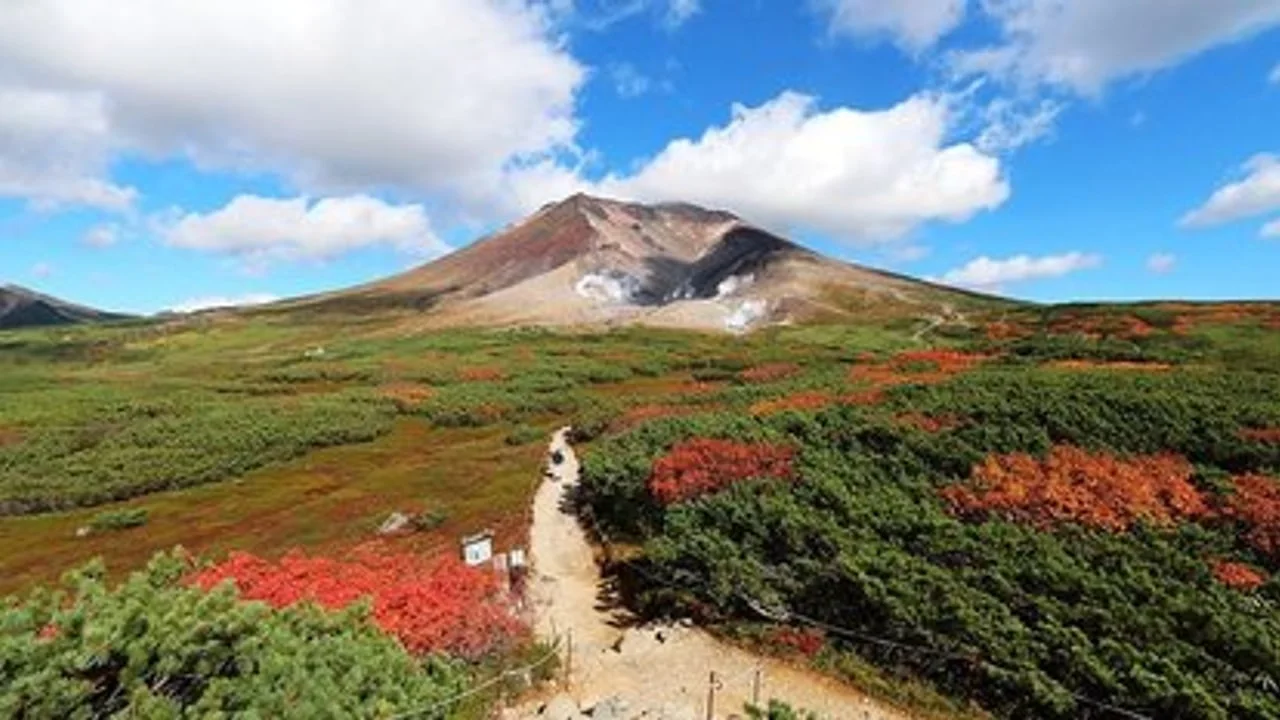
Mt. Asahidake (旭岳, 2,291 m) is Hokkaido's highest peak and the centrepiece of Daisetsuzan National Park, Japan's largest protected area. Unlike Mt. Fuji — where the trail is essentially a fixed queue — Asahidake has fewer foreign visitors, genuine volcanic terrain, and weather that turns fast and hard. Getting it right means understanding which of its routes suits your fitness, what gear the mountain demands at each season, and where you stand on permits and registration. This guide covers all of that, plus the Asahidake–Kurodake traverse if you want to push further.
At a glance
| Factor | Detail |
|---|---|
| Elevation | 2,291 m (7,516 ft) — highest point in Hokkaido |
| Mountain type | Active stratovolcano; visible steam vents below the summit |
| Location | Daisetsuzan National Park, Higashikawa, Hokkaido |
| Ropeway access | Asahidake Ropeway: base (670 m) → Sugatami Station (1,600 m) |
| Hiking season | Late June – late September (day trips); mid-July – early September (optimal) |
| Permit required | No permit. Trail registration form strongly recommended (see below) |
| Closest city | Asahikawa (~70 min drive; ~90 min by bus) |
| Trail fee | None (ropeway fare is a transport cost, not a climbing fee) |
| Fuji comparison | More technical than Fuji; unmarked volcanic rock above ropeway; weather is less predictable; far fewer crowds |
The mountain
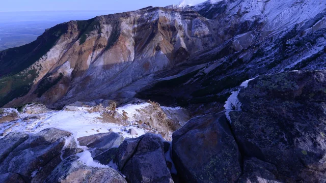
Asahidake is a stratovolcano that last erupted in 1739 and is still classified as active. At the Jigokudani ("Hell Valley") area visible from the trail, you will smell sulphur and see steam vents clearly. The route from the ropeway summit station to the peak crosses open volcanic scree with minimal trail markers — in fog, which arrives without warning, navigation becomes genuinely difficult. The Ainu people called the Daisetsuzan plateau Kamuimintara, meaning "playground of the gods." The scale of the landscape justifies that name.
Compared to Fuji, the elevation is lower, but the challenge is not. Fuji has a clear brown track of volcanic gravel worn by millions of boots. Asahidake above the ropeway is raw rock, with cairns as the primary navigation aid. There is no wristband system, no congestion management, and no hut chain to shelter in. You are on your own once you leave Sugatami Station.
Routes
Route 1: Ropeway → Summit and back (standard day hike)
This is the most common route for first-time visitors and for solo hikers without a guide.
| Segment | Distance | Ascent time | Descent time |
|---|---|---|---|
| Sugatami Station (1,600 m) → Summit (2,291 m) | ~3.5 km | 2–2.5 hrs | 1.5–2 hrs |
| Total round trip | ~7 km | — | 4–5 hrs total |
From Sugatami Station you walk a short boardwalk around Sugatami Pond (1 hr loop, optional warm-up), then the trail climbs directly up the open volcanic slope toward the summit. The terrain shifts from alpine meadow to loose scree. The final 300 m of elevation gain is the steepest and most exposed. The summit is flat-topped — look north across the Daisetsuzan plateau for views toward Kurodake and the broad volcanic caldera.
AllTrails rates this hike "hard" with an elevation gain of 675 m (2,211 ft) over 5.8 km (round trip from the ropeway station).1
Timing: Leave Sugatami by 9:00 at the latest for a day hike. The ropeway stops accepting upward-bound single tickets after 4:00 pm in peak summer and after 3:00 pm from late August to October — hikers caught above this cutoff without a return ticket must walk down, which is doable but long.2
Route 2: Walk up from Asahidake Onsen (non-ropeway ascent)
For fit hikers who want a longer day or want to avoid the ropeway cost, it is possible to walk up through the forest from Asahidake Onsen village to Sugatami Station, then continue to the summit. This adds approximately 1.5–2 hours and 500 m of elevation gain at the bottom. Most foreign visitors take the ropeway because the forest walk is less scenic and the additional fatigue affects performance above the ropeway.3
Route 3: Asahidake–Nakadake–Susoai Loop
A longer loop that circles the western flank of the mountain via Nakadake hot springs and Susoai-daira (the flower meadows below the summit). From Sugatami Station, you summit Asahidake (2,291 m), cross the ridge to Mt. Mamiya (2,185 m) and Mt. Nakadake (2,113 m), descend to the natural hot spring at Nakadake Onsen (one of few hot springs accessible by hiking trail in Japan), then loop back across Susoai-daira to Sugatami. Total distance: ~11 km; total time: 5–7 hours including breaks. This is the recommended mid-level option for hikers who find the basic summit route too short.3
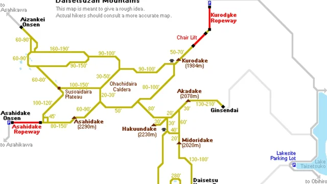
Route 4: Asahidake–Kurodake traverse (1–2 days)
This is the big one. The traverse links the two main peaks of Daisetsuzan National Park — Asahidake (2,291 m) in the west and Kurodake (1,984 m) in the east — with ropeway access at both ends. Most hikers do it as a two-day trip, overnighting at the Kurodake Refuge.
| Stat | Value |
|---|---|
| Total distance (one-way) | ~11 km (Sugatami → Kurodake Refuge); ~17 km if walking down to Sounkyo |
| Total elevation gain | ~770 m |
| Day 1 time | 4–5 hours to Kurodake Refuge |
| Day 2 time | 6–7 hours back to Asahidake Onsen |
| Difficulty | Intermediate–advanced; no technical climbing required |
| Best season | Mid-July – early September |
The traverse crosses an active volcanic caldera rim, passes Mt. Mamiya, Mt. Nakadake, Mt. Hokuchin, and Mt. Hokkai. After Asahidake the descent is steep — there is a fixed rope in the steepest section — but the remainder is rolling ridge with manageable exposure.3 The Kurodake Refuge is roughly 100 years old, costs ¥1,000 per person to camp nearby, and provides basic shelter, snacks, and water. Bring your own sleeping bag and food. The Kurodake Ropeway on the Sounkyo side costs around ¥1,380 one-way to descend to Sounkyo Onsen — check current fares as these change seasonally.5
Logistics for the traverse: You need transport at both ends. Arriving in Asahidake Onsen and departing from Sounkyo Onsen, or doing the circuit and returning to Asahidake, are both viable. The round-trip circuit (summit Asahidake → traverse to Kurodake → return same route next day) takes 2 days and ~32 km. Start from Asahidake if coming from Sapporo or Asahikawa — the logistics are simpler.
Difficulty and fitness
Standard day hike (Route 1): Moderate–hard. The ropeway removes the first 930 m of elevation gain, but the remaining 670 m on loose volcanic scree demands sure footing. No scrambling is required in summer; however, in fog (common) the lack of visible trail means you must navigate by cairn. A reasonable benchmark: if you have done Fuji's Yoshida Trail in a normal time, you will find this within range, though the terrain is more technical underfoot.
Nakadake loop (Route 3): Hard. Add 4–6 km and 2+ hours to the standard day hike; requires good endurance.
Kurodake traverse (Route 4): Intermediate–advanced. 2 days; 32 km round trip; significant exposure on ridge; navigation in low visibility requires map and compass or a GPS track.
Key physical risks:
- Altitude: 2,291 m is low enough that altitude sickness is rare, but possible in people with very low aerobic fitness.
- Volcanic gas: hydrogen sulphide in the Jigokudani zone. The Visitor Center posts daily gas readings; if the alert level is elevated, the zone may be closed.
- Cold and wind: summit temperatures in July average 5–10 °C; wind gusts above 10 m/s are common. At 14 m/s (checked live from the ropeway site on the date of writing), standing on the summit becomes difficult.2
- Navigation in fog: the most common reason people call mountain rescue on Asahidake.
Season and timing
| Period | Conditions | Recommended for |
|---|---|---|
| Late June – mid-July | Snowfields remain on north faces; cold (2–8 °C summit) | Experienced hikers with microspikes |
| Mid-July – mid-August | Full summer; alpine flowers peak; best weather window | Day trippers and traverse hikers |
| Mid-August – late September | Cooler; first snows possible from late September | Autumn foliage — see below |
| October | Trail may close; snow accumulates fast | Experienced winter hikers only |
Autumn foliage timing: Asahidake is consistently the first place in Japan to see autumn colours each year. The tundra around Sugatami and Susoai-daira turns scarlet and gold from mid-September, typically peaking around the third week of September. The japan-guide.com autumn foliage monitoring team begins its season reports here before any other Japanese mountain.4 The ropeway is extremely crowded on weekends and national holidays during this peak — arrive before 8:00 or expect a 30–45 minute ropeway queue.
コンテンツカードを読み込んでいます…
Weather unpredictability vs. Fuji: On Fuji, summer weather follows a relatively predictable daily pattern (cloud builds from mid-morning). Asahidake is inside Hokkaido's sub-arctic weather system, which means fronts arrive with little warning at any time of day. Wind speeds above 10 m/s at the summit station are common across most of the climbing season; the ropeway posts live conditions at Sugatami Station on its website. Always check before departing your accommodation.
Permits and registration
Entry fee: None. There is no climbing fee for Asahidake, unlike Mt. Fuji's current ¥4,000 trail conservation fee.
Permit: None required for any standard route.
Trail registration (登山届, tozandodoke): No legal requirement for Japanese national parks, but the Asahidake Visitor Center and all local accommodation strongly advise you to fill in a trail registration form before every ascent. The form records your planned route, departure time, and emergency contact. Completed forms are given to reception at your accommodation or the Visitor Center. In the event of an accident, rescue personnel use these forms to narrow the search area.7
Volcanic alert level: Asahidake is monitored by the Japan Meteorological Agency (JMA). At alert level 1 (normal), all routes are open. At alert level 2, the summit area above the ropeway may be restricted. Check the JMA volcanic activity page before each trip.
Gear checklist
Asahidake demands more layering than Fuji. The base at Asahidake Onsen is at 1,100 m and already cool; the ropeway takes you to 1,600 m. Summit temperatures in the core hiking season hover around 5–12 °C, dropping to near 0 °C in September.
Essential (do not skip):
- Waterproof jacket and trousers (not just a poncho — side wind makes ponchos useless)
- Insulating mid-layer (fleece or down jacket)
- Hiking boots with ankle support — the volcanic scree requires more ankle protection than Fuji's compacted path
- Trekking poles (rentable on-site — see below)
- Map or downloaded offline GPS track (trail markers are cairns only above the ropeway)
- Headlamp with fresh batteries
- At least 2 litres of water (there are no water sources above the ropeway; the Visitor Center sells water)
- Bear bell (brown bears are present in Daisetsuzan; low forest sections are the main risk area)
- Emergency whistle and space blanket
- Snacks for 5–6 hrs
For the traverse only:
- Sleeping bag rated to at least 0 °C (the Kurodake Refuge is basic; bring your own)
- Tent (camping available near the refuge)
- Water filter or purification tablets
- 2-day food supply
Microspikes (late June / early October): Snow lingers on north-facing gullies above 1,800 m until mid-July. If you are going early or late in the season, carry microspikes.
Gear sourcing: rent, buy, or bring
Option A: Rent at the Asahidake Visitor Center (best for day hikers)
The Visitor Center at the base of the ropeway rents basic gear. As of the latest published rates:8
| Item | Daily rate |
|---|---|
| Ski/trekking poles (fixed length) | ¥500 |
| Collapsible trekking poles | ¥1,000 |
| Rubber boots | ¥500 |
| Snowshoes (includes poles) | ¥1,000 (Mont-bell members: ¥900) |
| Cocoheli GPS beacon rental | ¥1,100/day (+ ¥550 each additional day) |
Hours: 9:00–17:00; return by 16:30.
Payment: Cash or credit card.
Note: Only basic poles and snowshoes are available. The Visitor Center does not rent jackets, sleeping bags, or boots for mountaineering. Boot rentals at the ropeway's Sugatami Summit Station cover rubber boots suitable for the Sugatami Pond loop only, not for the full summit ascent.
Option B: Rent a full kit in Asahikawa city (best for overnight/traverse hikers)
Asahikawa Ride (旭川 Ride) is a gear rental service based in Asahikawa city, purpose-built for hikers heading to Asahidake and Mt. Tokachi. They rent tents (NEMO, Montbell models), sleeping bags (Isuka), sleeping mats (NEMO Switchback), trekking poles, headlamps, bear bells, and packaged sets.9 Booking is done online; equipment can be picked up in Asahikawa on your way to Asahidake Onsen.
This option is strongly recommended for overnight or traverse hikers who have not brought camping gear from home.
Option C: Buy gear in the Asahikawa/Higashikawa area
Mont-bell Daisetsu Higashikawa store (モンベル 大雪ひがしかわ店) is the closest outdoor retail shop to Asahidake Onsen. Higashikawa is approximately 40 minutes from Asahidake Onsen by car. Mont-bell is Japan's largest outdoor retailer; their prices for layering and rain gear are competitive by global standards.10
For a broader selection, Asahikawa city (40 min from Higashikawa) has additional outdoor chains.
Rent-vs-buy comparison (standard day hiking kit)
| Item | Buy new (approx.) | Rent/day at Visitor Center | Break-even |
|---|---|---|---|
| Trekking poles (pair) | ¥3,000–8,000 | ¥500 | 6–16 days of rental |
| Waterproof jacket | ¥8,000–25,000 | Not available locally | Buy if hiking 3+ days in Hokkaido |
| Hiking boots | ¥12,000–30,000 | Not available locally | Buy if you'll hike multiple mountains |
| Full traverse kit (tent + bag + mat) | ¥40,000–80,000 | ~¥3,000–5,000 (Asahikawa Ride set) | Buy only if regular backpacker |
Verdict for a single trip: Rent poles and snowshoes at the Visitor Center for a day hike. For the traverse, book a full kit from Asahikawa Ride before arriving. If you are hiking multiple Hokkaido peaks in one trip, a Mont-bell stop in Asahikawa or Higashikawa makes financial sense for mid-layers and rain gear.
Getting there from major Hokkaido hubs
From Asahikawa
By bus (Ideyu-go, line 66) — operated by Asahikawa Denkikidou:4
| Departure | Asahikawa Station | Asahikawa Airport | Arrives Asahidake Onsen |
|---|---|---|---|
| Morning | 07:15 | 08:00 | 09:03 |
| Late morning | 09:15 | 10:00 | 11:03 |
| Afternoon | 12:15 | 13:00 | 14:03 |
| Late afternoon | 14:15 | 15:00 | 16:03 |
Return buses from Asahidake Onsen: 09:55, 11:55, 14:55, 16:55.
Fare: ¥1,800 one way from Asahikawa Station; ¥1,270 from Asahikawa Airport.
Journey time: ~90 minutes from Asahikawa Station; ~60 minutes from the airport.
By car: ~70 minutes from JR Asahikawa Station; ~60 minutes from Asahikawa Airport. Follow Route 1160 / 1160 toward Higashikawa then Asahidake Onsen. Parking at the ropeway: ¥500/day for regular cars; free November–May.
From Sapporo
No direct bus to Asahidake Onsen from Sapporo. The standard routing is:
- Hokkaido Shinkansen / Limited Express from Sapporo to Asahikawa (1.5 hours, ~¥4,800 with JR Pass or ~¥4,690 reserved seat)
- Ideyu-go bus from Asahikawa Station to Asahidake Onsen (~90 minutes, ¥1,800)
Total from Sapporo: approximately 3 hours, ¥6,000–7,000.2
By car from Sapporo: ~3 hours (200 km via Hokkaido Expressway).
The ropeway
The Daisetsuzan Asahidake Ropeway runs from the base station in Asahidake Onsen (670 m) to Sugatami Station (1,600 m). Journey time is approximately 10 minutes.2
| Season | Round-trip fare (adult) | One-way fare |
|---|---|---|
| Peak season (Jun 1 – Oct 31) | ¥3,500 | ¥2,200 |
| Regular season (Nov 1 – May 31) | ¥2,800 | ¥1,700 |
Operating hours:
- June 1 – June 19: 9:00 am – 5:00 pm (every 20 min)
- June 20 – mid-October: 6:00 am – 6:00 pm (every 15 min on weekdays; varies at weekends/holidays)
- October onwards: 9:00 am – 4:00 pm; temporarily closed mid-November to late November for maintenance
Upward-bound single tickets are not sold after 4:00 pm in June–August or after 3:00 pm in late August–October. Check the live schedule page before your trip as hours change monthly.
Where to stay
Asahidake Onsen is a small cluster of hotels, ryokan, and a hostel at the mountain's base (~1,100 m). It has no convenience stores — stock up in Asahikawa or Higashikawa before arriving.
K's House Daisetsuzan is the main budget option and a well-run hostel with onsen access, kitchen, and English-speaking staff. Popular with international hikers; dorm beds typically ¥3,500–5,000/night.
Ryokan options (mid-range) include several traditional inns in Asahidake Onsen, most with included dinner and breakfast. Rates typically ¥10,000–25,000/person/night. Booking in advance is essential during the autumn foliage peak (mid–late September) and weekends in summer.
Accommodation tip: Staying the night before and the morning after your hike in Asahidake Onsen rather than commuting from Asahikawa means you can take the first ropeway (from 6:00 am in peak summer) and be at the summit before cloud builds. This matters especially in August.
Foreigner-specific notes
- English on-site: The Visitor Center has English-language maps and staff who speak basic English. The ropeway website and live conditions page are in English. Trail markers above the ropeway are Japanese-only cairns.
- Bear safety: Brown bears (Ursus arctos yesoensis) inhabit Daisetsuzan. Sightings near the lower forest trails are reported each season. Carry a bear bell from the trailhead and make noise in any forested section. Ask the Visitor Center for the current bear activity report.3
- Emergency services: In an emergency, call 110 (police/rescue). The ropeway website instructs hikers to call 110 for mountain rescue, not 119.2
- Drone regulations: Unmanned aerial vehicles require advance permits from relevant government agencies; operating one without a permit inside the national park will result in immediate confiscation. Leave drones at home.
- Cash: Asahidake Onsen accommodations generally accept credit cards, but small trail-facing vendors and the Visitor Center rental desk may be cash-only.
- No Fuji-style trail markers: The coloured trail marker poles that guide Fuji hikers every 20 metres do not exist here. Before you go, download the Yamap or Gaia GPS app and the Daisetsuzan map pack.
Comparison: Asahidake vs. Mt. Fuji at a glance
| Mt. Fuji | Mt. Asahidake | |
|---|---|---|
| Elevation | 3,776 m | 2,291 m |
| Ropeway/bus to trailhead | Buses to 5th Station (2,305 m) | Ropeway to 1,600 m |
| Trail type | Compacted volcanic gravel, well-marked | Open volcanic scree, cairn navigation |
| Crowds | Very high (peak: 4,000+ climbers/day) | Low–moderate |
| Autumn foliage | None above treeline | Japan's first; peaks mid-September |
| Active volcanics | Dormant | Active steam vents |
| Permit/fee | ¥4,000 trail fee (all trails, 2025) | None |
| Recommended season | July 1 – early September (official window) | Mid-July – late September |
| Overnight option | Mountain huts on trail | Kurodake Refuge (basic) |
Check the live status of the ropeway and summit weather at asahidake.hokkaido.jp before departure. Mountain conditions change quickly; the ropeway posts temperature, wind speed, and visibility at Sugatami Station updated throughout the day.
参考ソース
- 1AllTrails — Mt. Asahidake
- 2Daisetsuzan Asahidake Ropeway — Schedule & Fares
- 3Let's Talk Trail — Asahidake to Kurodake Traverse
- 4Japan Guide — Asahidake Onsen
- 5Yamakei Online — Asahidake–Kurodake Traverse
- 6Pexels — シゲル タカイ
- 7Asahidake Visitor Center — Access & Information
- 8Asahidake Visitor Center — Rental
- 9Asahikawa Ride — Trekking Gear Rentals
- 10Yelp — Outdoor Gear near Asahikawa
このコンテンツについて、さらに観点や背景を補足しましょう。